 Many of our reserves have an important past to Māori and non-Māori residents. The Whakatāne District includes important early establishment sites for Polynesian explorers. These people, the greatest ocean navigators the world has known, found a place to settle here. Their descendants live here still. We remember them and all the peoples in between through stories attached to important places.
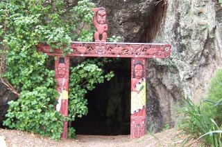
Muriwai's Cave
Drive out to the Whakatāne Heads, and opposite the boat ramp car park you will find a small cave named for Muriwai, an ancestor who is reputed to have dwelt there. Muriwai was a powerful and influential woman, and her descendents tie Ngati Awa to a number of other iwi. The cave is sacred to her memory. Please do not eat or drink in the cave.
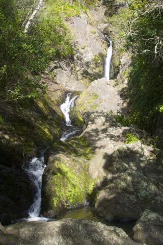
Wairere Waterfall
 The Wairere Waterfall was one of three landmarks given to Toroa, captain and navigator of the Mataatua waka, by his father Irakewa. The falls are one of the most beautiful and historically significant sites in Whakatāne. The falls are lit in the evening and are worth a visit day or night. Please do not bathe in this water or eat or drink near the falls.
Kaputerangi Reserve
This reserve lies adjacent to the trig station on the top of the hill between the Wairaka suburb of Whakatāne and Otarawairere. Kaputerangi is thought to be one of the oldest settlement sites in New Zealand. The magnificent views from the reserve demonstrate its strategic importance. You can imagine occupants scanning the horizon, anxiously awaiting the arrival of a voyaging waka (canoe). The line of ancestors associated with this place is long and significant. Please respect this area.
Hillcrest Road Lookouts
Two small reserves are accessed from a car park off Hillcrest Road. Each has a short climb to lookout sites offering magnificent views.
Puketapu Lookout
Puketapu (sacred hill) has been a lookout site for the Ngati Awa tribe for over 600 years. In 1965, the Whakatāne Rotary Club developed the site as a lookout and reserve, providing fine views of the town and river mouth.
Papaka Redoubt Historic Reserve
This former Māori pa site, later used as an Armed Constabulary Redoubt, serves as a lookout and is accessible from Hillcrest Road, opposite the car park at the junction of Seaview Road. The redoubt offers a different perspective of Whakatāne and the Rangitaiki Plains.
Wharaurangi
To be connected to the stars and the universe
Before the arrival of the Mataatua Waka, this land was home to Toi-te-Huatahi. Toi made landfall hundreds of years ago at Kākāhoroa (Whakatāne) and through his son Awanuiārangi descend the Ngāti Awa, whose descendants occupy Whakatāne and surrounding areas today.
Toi named the area surrounding Pōhaturoa ‘Wharaurangi’, to acknowledge the role of the constellations in guiding navigators across the Pacific Ocean to Aotearoa. Prior to harbour reclamation, the waters of Ōhinemataroa (Whakatāne River) rose to the base of Pōhaturoa, where the toka (rock) Wharaurangi stood.
On this site, matters of war and peace were discussed and debated. Rituals such as karakia, tā moko, kōiwi cleansing and, later, christenings would also occur here. Wharaurangi was occupied until it was sacked by Te Kooti Rikirangi in March 1869, and then briefly occupied again in the early-1870s.
In 1940, descendants of the Ngāti Awa leaders who were signatories to Te Tiriti o Waitangi gathered at Pōhaturoa to re-enact its signing in Whakatāne on 16 June 1840. Each year, Ngāti Awa commemorates the Treaty signing at Pōhaturoa on that day.
Today, Wharaurangi remains a significant site for Ngāti Awa and is used as a place to gather for important commemorations and events.
He korero riri ki Wharaurangi; he hei matau ki Otuawhaki
War talk emanates from Wharaurangi; fishing expeditions from Otuawhaki