
We've put together some handy resources for you to learn more about climate change and its likely impacts on our region.
Climate Change E-Learning Hub
We've created a Climate Change E-Learning Hub with heaps of information and resources that cover a variety of climate change-related topics.
There are four modules to explore:
- Start here, E-Learning Hub introduction
- Module 1 - Climate Change 101
- Module 2 - The need to act now
- Module 3 - Our role and responsibilities
- Module 4 - Tools for our response
These modules have been designed to be a source of accurate and engaging information on climate change. The material includes YouTube clips, TED Talks, scientific articles, academic research, recent publications and reports.
Disclaimer: The information included in this e-learning hub has been compiled by Whakatāne District Council to guide us, and our communities, on a learning and development journey. The Council does not own, and is not the author of, most of the content included in this hub. The Council has compiled content believed to be relevant, engaging and wherever possible, provide a local context. More information regarding Council’s climate change project, including our principles and current engagement opportunities, can be found on our project page.
What is climate change?
Earth's atmosphere is made up of oxygen, a large amount of nitrogen and a small percentage of greenhouse gases (GHGs), such as carbon dioxide and methane. GHGs act like a blanket around the Earth. They trap warmth from the sun and make life on Earth possible. Without them, too much heat would escape and the surface of the planet would freeze. However, increasing the concentration of GHGs in the atmosphere causes the Earth to heat more and the climate to change.
The climate has changed throughout history. However, the planet is experiencing a warming trend that is significant because it is extremely likely to be the result of human activity since the mid-20th century. The warming is happening faster than has been seen in recent history.
Learn more about climate change's impact on the Bay of Plenty by reading the Bay of Plenty Regional Council and NIWA report - (PDF, 13.6 MB) or check out this great video from Bay of Plenty Regional council.
What a changing climate will mean for the Whakatāne District
Ngā whakaaweawetanga o te huringa āhuarangi ki te rohe nei
Climate is about so much more than just weather. For us as a community, the things we love about this place we call home are at risk, including swimming in our waterways, our cultural taonga and historic places, tramping in our bush, fishing in our ocean, abundant food production, even the homes we live in. Our climate directly impacts on our local culture, economy, wellbeing, health and environment.
The Bay of Plenty Regional Council Toi Moana, in collaboration with councils in the region, have commissioned a Regional Risk Assessment, to help show how a changing climate may look for the Whakatāne District.
Summary of projected changes to the Whakatāne climate by 20901:
| Climate hazard/variable | RCP 4.5 (2090) | RCP 8.5 (2090) | Sub-district Variation |
|---|---|---|---|
| Air Temperature | ↑ 1 - 1.5°C * | ↑ 2.5 - 3°C* | Consistent mean temperature increases within Whakatāne District. |
| Hot Days (>25°C) | ↑ 20 - 40 more hot days | ↑ 40 - 90 more hot days | Most of Whakatāne District is projected to experience large increases in the number of hot days, particularly along the Rangitāiki and Tarawera Rivers. |
| Drought | ↑ 80 - 14mm of Potential Evaporation Deficit (PED) (coastal) ↑ 60 - 100mm of PED (inland) | ↑ 120 - 160mm of PED (coastal and Rangitāiki River) ↑ 60 - 120mm of PED (elevated) | Coastal Whakatāne District and inland areas surrounding the Rangitāiki River are projected to experience relatively large increases in of PED (which indicates an increased potential for drought) |
| Frost Days (<0°C) | ↓ 2-6 days (coastal areas) ↓↓ 2 - 5 days (inland) | ↑ 6 - 8 days (coastal areas) ↑↑ 4 - 30 days (inland) | Inland elevated areas experience the greatest number of frost days at present and are projected to experience the greatest in frost days in future. |
| Rainfall | ↑ 0 - 8% increase in winter rainfall ↓ 0 - 10% decrease in spring rainfall | ↑ 2.8% increase in winter rainfall ↓ 4 - 10% decrease in spring and summertime rainfall | ↑ Winter rainfall increases the most near the coast. Extreme rainfall events across the region are projected to become three times more frequent |
| Sea level rise | ↑ 0.55 m | ↑ 0.74 m | Vertical land movement (VLM) may influence the effect of sea level rise on land areas as follows:
|
1 Bay of Plenty Regional Risk Assessment
* Mean temperature increases relative to recent 1986 - 2005 baseline
Representative Concentration Pathway (RCP) is a greenhouse gas concentration trajectory adopted by the Intergovernmental Panel on Climate Change (IPCC) and the two scenarios used in this modelling include the 'Fossil-fuel intensive scenario' (RCP8.5) and the ‘Middle of the road scenario’ (RCP4.5). Refer to the Bay or Plenty Regional Climate Change Risk Assessment -District Summaries for more information.
Snapshot of climate change hazards in the Whakatāne District
He whakarāpopototanga o ngā matepā huringa āhuarangi i te rohe o Whakatāne
The Bay of Plenty Region and Whakatāne District are already vulnerable to natural hazards including flooding, coastal inundation, and land subsidence (the sinking or settling of the ground’s surface). Climate change is likely to make the consequences of these hazards worse.
 Marae locations
  State Highway
  Railway
  River and surface flooding
  Coastal Flooding
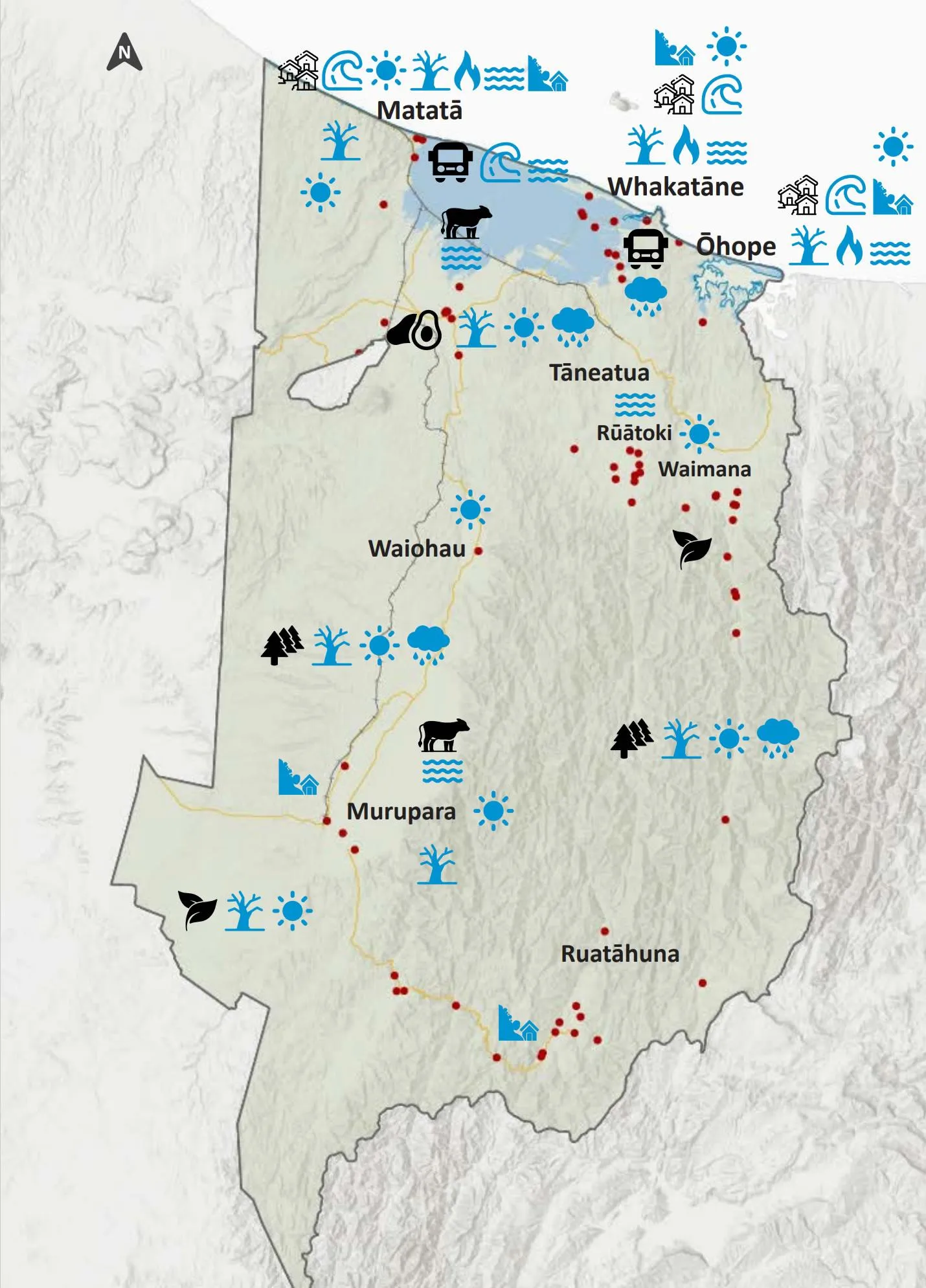
Adapted from the Bay of Plenty Regional Risk Assessment
Elements at risk
![]() Communities and settlements
Communities and settlements
Whakatāne and other coastal settlements within Whakatāne District may be exposed to increasing coastal hazards.
![]() Horticulture
Horticulture
Kiwifruit and avocado orchards on the Rangitāiki Plains may face increased flooding, groundwater rise and salinity stress. Orchards may also suffer from reduced winter chill, drought and increasing damage from severe weather.
![]() Agriculture
Agriculture
Farms on the Rangitāiki Plains may face increased flooding, increasing heat stress and increased pests and diseases.
![]() Forestry
Forestry
Kāingaroa Forest is at risk of damage from increasing extreme weather, drought, landslides and fire risk, as well as disruption to logging connections due to flooding of transport routes.
![]() Native ecosystems
Native ecosystems
Native forests within Te Urewera ranges and the frost flats are at risk from increasing temperatures. Increasing rainfall may increase sediment in rivers and cause sediment plumes to discharge, causing damage to coastal ecosystems.
![]() Transport
Transport
The roading network may face increasing damage and disruption from inundation, surface flooding, landslides, slips and sea level rise closing or damaging many rural roads, State Highway 2, low lying roads (such as Wainui and Thornton Roads), bridge structures and culverts, increasing disruptions and maintenance costs and leading to people being isolated. The Murupara and Matatā rail lines and the Whakatāne Airport may also face increased damage and disruption.
Hazards
|
|
|
What can I do about climate change?
Climate change impacts us all, and we need to respond at a global, national, local, and individual level. We need to mitigate climate change (reduce the emission of GHGs), and adapt to the impacts we are already seeing by changing the way we live and do things. The worst effects of climate change can be mitigated if GHG emissions are reduced to net zero over the course of this century.
Our Climate Pathway provides a framework for the whole district to work towards, collaboratively. The Action Plan identifies over 200 actions for the Council, businesses, community groups, whānau and individuals to work towards.
There are also some great online resources to help you take climate action:
At home
Gen Less
The Gen Less website provides practical advice and information about how to live a lower carbon lifestyle, including reports to help inform those life choices like investing in solar, of the true facts behind electric vehicles.
Future Fit
Provides a quick and simple free carbon calculator, with ideas about how you can reduce your carbon footprint.
Ministry for the Environment
Includes ideas of action you can take at home and in your community to enhance our environment.
At work
Gen Less
Provides pragmatic advice for those businesses starting out on their climate journey, from calculating your emissions, setting a plan, transitioning to a low-energy operation, to funding opportunities and networks
Climate Action Toolbox
This Climate Action Toolbox helps businesses to learn, measure and act on your climate goals. With case-studies, tailored actions and tracking over time.